

Products and Services
Our satellites - TEE constellation (Tianyan Remote Sensing Constellation System)
Our planned TEE constellation consists of 1 optical remote sensing satellite with 1-meter resolution, 10 with 0.75-meter resolution, and 2 with 0.5-meter resolution. As of November 2024, one 0.5-meter resolution optical remote sensing satellite is already in orbit. Once fully deployed, the TEE constellation will enable a rapid emergency response time of just 1.2 hours. Additionally, we have access to 18 commercial ground station partners worldwide, significantly accelerating our data transmission capabilities and allowing us to deliver high-precision, high-efficiency remote sensing imaging services to global clients.
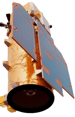
TEE-01B
On June 6, China successfully launched TEE’s The Earth Eye-01B satellite into its designated orbit using the Ceres-1 Y13 launch vehicle at the Jiuquan Satellite Launch Center. The mission was completed successfully.
The TEE remote sensing constellation consists of three low-Earth optical satellites, offering panchromatic imaging with sub-meter resolution and multispectral imaging services. The constellation covers the entire globe with daily revisit capabilities, and is designed for applications in agriculture, ocean monitoring, emergency management, natural resource supervision, and municipal transportation.
TEE-01B, the first satellite of the TEE constellation, was deployed at an orbital altitude of 545 km. It carries a panchromatic/multispectral optical remote sensing camera, capable of achieving 0.53-meter panchromatic and 2.12-meter multispectral resolution. Its applications include crop census, island surveillance, early disaster detection, topographic mapping, and infrastructure inspection.
Prior to launch, the Ministry of Industry and Information Technology organized and completed the necessary frequency coordination procedures and officially issued the license, providing TEE with radio frequency and orbital resources to support the establishment of a commercial remote sensing satellite constellation.


Satellite Design Indicators
Orbital Altitude
535km
Resolution
0.52 m (panchromatic), 2.08 m (multispectral)
Swath Width
14.8km
Spectral Bands
Panchromatic, Blue, Green, Red, Near-Infrared
Imaging Modes
Standard push-broom, Stereo, Along-track imaging
Weight
<112kg